
Serengeti National park map
Serengeti National park map : The Serengeti National Park map depicts not just the boundless open plains of the Serengeti National Park, but also the adjacent Serengeti ecosystems that are part of the larger Serengeti ecosystem. The park is bordered on both sides by national wildlife reserves, including the Kenya Maasai Mara Game Reserve in the north, the Ngorongoro Conservation Area in the south, and the Loliondo Game Control Area in the East.

The Serengeti national park map also shows the Serengeti national park location, the Serengeti district. The Serengeti district is one of the seven districts that make up the Northern Arusha region of Tanzania’s Mara region. The district is run by administrative cells, with the district headquarters in Mugumu town, which is located in the park’s western section, near the Western Gate. The Mara area, located in northern Tanzania, is one of the country’s most well-known regions, formerly known as the Lake Region during colonial administration and later renamed the Mara region. The Mara region is bordered on the southeast by Arusha, on the north by Kagera, and on the south by Mwanza. It highlights all the boundaries of the district as well as the divisions that make up the Serengeti district.
Many geographers have created numerous geographical maps to depict the park’s natural features. The map of Serengeti National Park also depicts the park’s geographical features, which serve as major tourist attractions. The park’s boundaries are also shown on the map from every angle. The map is well detailed showing the key and important areas at the park. It also highlights the animal concentration areas in specific periods like water pools.
On geographical features the key areas of consideration include the rivers, the rivers are subdivided in to two those are seasonal rivers and permanent rivers. The seasonal rivers dry off during the dry spell while the permanent rivers are all year around. The major two rivers arte Grumeti river in the West and Mara river in the North. These are the two points where the wildebeest migration crosses the deadly rivers.
Tanzania’s Ngorongoro Crater Conservation Area and other near by game reserves located within the park’s boundaries also included. Serengeti National Park’s map also shows gates. The map shows all of the park’s entrance points from every angle. The open savannah grasslands of the park, along with their various ecosystems, are also depicted on the map.
The Serengeti Map depicts the wildebeest migration areas that encompass the entire Serengeti National Park. The park is divided into five regions, which are as follows: The wildebeest migration has no leader but the migration remains moving clock wise direction only. The entry point is different from exit point. This is one of the unique features of the great wildebeest migration. The exit Serengeti in the North to Masai mara national park and enter back to Serengeti in the South around Ngorongoro conservation area. The movement is repeated annually in the same direction.
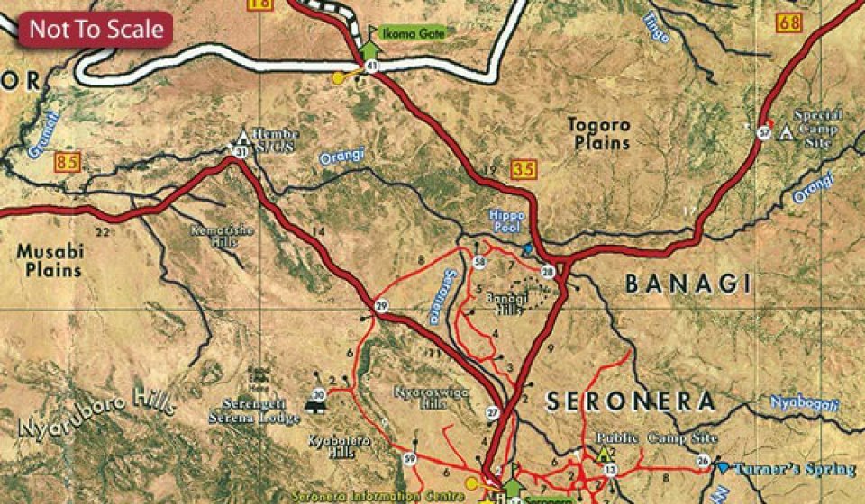
Seronera Area
The central region, also known as Seronera, is the most popular and well-known among visitors. It has an airfield that exclusively accepts domestic flights. The region contains a tiny river that attracts a lot of animals, particularly during the dry season. The Seneroa region includes additional lodgings, primarily luxury hotels, as well as a guest information center, a petrol pump, and the Tanzania Wildlife Authority headquarters, as well as a park for public buses that travel directly to Arusha from the park.
The Serengeti of the East
The Serengeti’s eastern side includes the Grumeti River, where little movement occurs after the massive Masai Mara wildebeest migration in October and November, which passes via Lobo, Western Loliondo, and the Ngorongoro Conservation Area’s Gol Mountains. Serengeti North
The annual wildebeest migration, which takes place between June and October and involves wildebeests crossing the Mara River from Serengeti National Park to the Kenyan Masai Mara, is well-known.
Serengeti South
This region is close to or borders the Ngorongoro conservation area, which is quite crowded during the calving season in February and March.
Serengeti West
Primate species such as the patas monkey, black and white colobus, Baboons, and others are well-known in this area. Other creatures like as lions, cheetahs, and others may also be spotted in this region. The wildebeest migration cross this area around June as they head to the Northern part of Serengeti to Mara region.
The map of the Serengeti National Park is an excellent resource for visitors planning their first safari to the park. It shows you the main routes to take and the gates from which you can enter the park depending on which route you take. If you’re looking for a place to stay, make sure it’s within the Serengeti National Park’s boundaries. This will give you enough time to enjoy the park’s full day of activities. Without such a guiding map most guests who have never been at the park are mislead.
Our Serengeti national park map is a digitalized and satellite map that shows all the current part of the park. In conclusion, use enough time to thoroughly review our Serengeti National Park map for self-direction. You will be aware of all park entrances, avenues for park activities, and the location of park lodgings. This will allow you to arrange the proper lodgings for your safaris since you will know the distance between the lodge and the park gate if it is located outside of the park. To enjoy more action one has to consider using the lodges that are located inside the park This will allow you to enjoy 24 hours of the park entrance fees. If one is staying out his or her park entry fees expire as soon as you exit the park. The map also guides you to book the lodge following the migration calendar. For example around June the best area to stay is central Serengeti and Western Serengeti while from July to August the best place should be in Northern Serengeti around Mara region. Seronera area is the only place that is busy throughout the year hence most lodges are concentrated around this area.

